Retracing the steps of a Victorian rambler
 |
| Sketch of St Mary's church, North Mymms Probably drawn by Bernard Alfieri in the early 1890s |
He'd plotted a route that would take him from Potters Bar, through Water End, past St Mary's Church North Mymms, then over to South Mimms, through Shenley and on to Radlett, where he would catch the train home.
We've retraced his steps from Potters Bar through the North Mymms part of the walk to compare and contrast what he saw and wrote about then with what the modern-day rambler is likely to see if they walk a similar route today.
At the time Alfieri was working on a book to be called 'Half-holidays with the camera'. At first it seems a strange title, because there are no photographs in the book, just maps and 50 pen-and-ink sketches, including the one of St Mary's Church, North Mymms (above).
But it seems that the book was never meant to be a collection of photographs. Its purpose. it appears, was to list photogenic landscapes, villages, and buildings within a train ride of the capital. And it was part-funded by the half dozen photography-related adverts at the front and back of the book, such as the two below. So the target audience was clear; people who could afford cameras, were able to travel, and enjoyed the countryside.
You will notice that Alfieri refers to North Mymms as North Mimms. This is because the parish has had many name changes over the years.
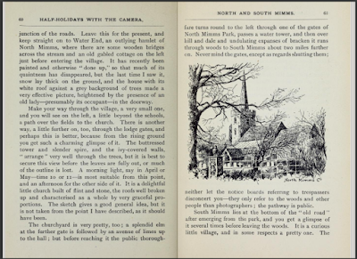
Alfieri's description of the route through North Mimms, as it was known at the time, along with a hand-drawn map, were to make up chapter nine called 'Potter's Bar, Mimms, and Shenley'. Note the possessive use of the apostrophe in Potter's, dropped in modern times.
Alfieri had walked the route before. He writes about visiting North Mimms in the snow, and again in the spring when he suggests the best time for taking photographs of St Mary's Church is in the mid morning. So he was familiar with the landscape.
Throughout this piece we set out Alfieri's description of the route in italics, and add pictures taken in the early 1900s - along with pictures taken in May 2018 when this feature was first published.
The journey to Hertfordshire
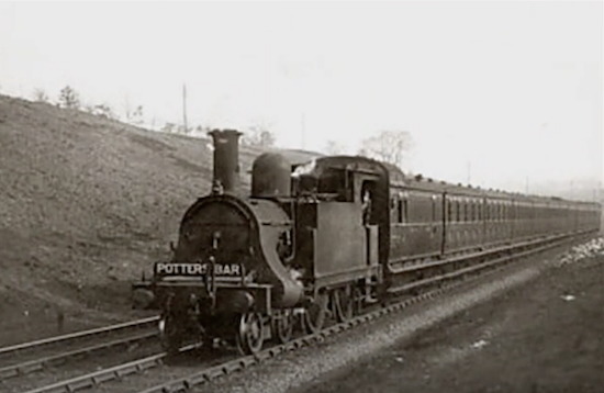 |
| Stream train heading to Potters Bar - still image taken from YouTube Date and copyright unknown |
"The nearest railway station to North and South Mimms is Potter’s Bar, reached by the Great Northern from King’s Cross or the lines connecting with it at Finsbury Park. It is rather a long way out, perhaps, but not too far for a Saturday afternoon’s excursion on a summer day."It is interesting that Alfieri saw the trip as an "afternoon's excursion", because the route of the walk he describes is at least 10-miles long. We have covered just six miles of his route, joining it at Potters Bar station, and leaving it at South Mimms where, on the return leg, Alfieri headed south-west to Radlett to catch a train home.
Arriving at Potters Bar
 |
| Potters Bar Station - still image taken from YouTube Date and copyright unknown |
"At Potter's Bar Station, instead of turning under the bridge in the direction of the town, take the other way as far as the first finger-post, only a few yards up the road. It directs on the right to North and South Mimms via Mutton Lane, a good road at most times, and very charming in summer."
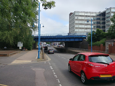 |
| The Darkes Lane bridge at Potters Bar station Image by the North Mymms History Project |
[Still to source and insert - an old picture of Mutton Lane junction and/or railway bridge]
 |
| The Darkes Lane Mutton Lane junction at Potters Bar station Image by the North Mymms History Project |
 |
| The view north-west over to North Mymms from Mutton Lane Image by the North Mymms History Project - Creative Commons BY-NC-SA 4.0 |
The descent to Mimms Hall
[Still to source and insert - an old picture of Mimms Hall]
"About a mile and a half up it takes a sudden turn in a northerly direction, then at the foot of a slight descent you come across Mimms Hall, now a farmhouse. This is worth looking at for its gables and haystacks surrounded by tall trees, mostly poplars."
Alfieri would probably have walked down Warrengate Lane, now a busy cut-through to Swanland Road, although the traffic can be avoided by taking a footpath that skirts Mimms Hall affording views of the old building. Perhaps this is the route Alfieri too, because he may have not been able to see the detail he described from the lane.
 |
| Mimms Hall from the public footpath Image by the North Mymms History Project - Creative Commons BY-NC-SA 4.0 |
The path down to Mimmshall Brook
[Still to source and insert - an old picture of the bridge over Mimmshall Brook and Warrengate Lane]
"You will notice, winding side by side with this pretty lane, a little stream it is a branch of the river Colne, and in many places is very picturesque, whether swollen by heavy rains or nearly dry from long-continued drought."
At the bottom of the path, where it joins Warrengate Lane and meets the bridge over Mimmshall Brook, is a small cottage that would have been there when Alfieri walked this way. Nowadays it's a cattery.
 |
| Warrengate Lane crossing the bridge over Mimmshall Brook Image by the North Mymms History Project - Creative Commons BY-NC-SA 4.0 |
The road to Water End
[Still to source and insert - an old picture of the road to the south of Water End and/or the cottages he was writing about]
"Keep straight on to Water End, an outlying hamlet of North Mimms, where there are some wooden bridges across the stream and an old gabled cottage on the left just before entering the village. It has recently been painted and otherwise done up so that much of its quaintness has disappeared, but the last time I saw it, snow lay thick on the ground, and the house with its white roof against a grey background of trees made a very effective picture, heightened by the presence of an old lady - presumably its occupant - in the doorway."Alfieri was probably writing about the row of cottages known as Mother Chuck's Cottages on the west side of Warrengate Road just before the junction with Bradmore Lane.
 |
| Cottages on the west side of Warrengate Road close to Water End Image by the North Mymms History Project - Creative Commons BY-NC-SA 4.0 |
The hamlet of Water End
[Still to source and insert - an old picture of the south end of Water End with cottages]
"Make your way through the village, a very small one and you will see on the left, a little beyond the schools, a path over the fields to the church."That route is now blocked by Swanland Road and the A1 (M), but today's walker can still follow Alfieri's directions by taking a footpath over the motorway to Tollgate Road and the footpath over the fields he was referring to. Below a few pictures of Water End cottages past and present along with the footpath over to the church.
 |
| Water End cottages Image by the North Mymms History Project - Creative Commons BY-NC-SA 4.0 |
[Still to source and insert - an old picture of Water End cottages]
 |
| A Water End cottage and the former Old Maypole pub Image by the North Mymms History Project - Creative Commons BY-NC-SA 4.0 |
 |
| The former Old Maypole pub, Water End Image by the North Mymms History Project - Creative Commons BY-NC-SA 4.0 |
[Still to source and insert - an old picture of The Old Maypole]
[Still to source and insert - an old picture of The Woodman Inn]
 |
| The Woodman Inn, Water End Image by the North Mymms History Project - Creative Commons BY-NC-SA 4.0 |
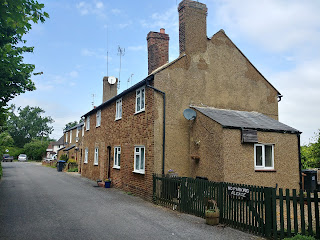 |
| Water End cottages Image by the North Mymms History Project - Creative Commons BY-NC-SA 4.0 |
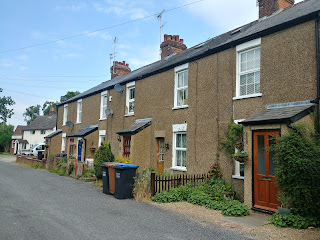 |
| Water End cottages Image by the North Mymms History Project - Creative Commons BY-NC-SA 4.0 |
 |
| The footpath approach to St Mary's Church Image by the North Mymms History Project - Creative Commons BY-NC-SA 4.0 |
St Mary's Church, North Mymms
[Still to source and insert - an old picture of St Mary's Church]
"There is another way, a little further on, too, through the lodge gates, and perhaps this is better, because from the rising ground you get such a charming glimpse of it. The buttressed tower and slender spire, and the ivy-covered walls, arranged very well through the trees, but it is best to secure this view before the leaves are fully out, or much of the outline is lost. A morning light, say in April or May—time 10 or 11—is most suitable from this point, and an afternoon for the other side of it. It is a delightful little church built of flint and stone, the roofs well broken up and characterised as a whole by very graceful proportions."
[We need a paragraph here explaining why the steeple is no longer on top of the church]
Alfieri offered a slight detour at this point to view St Mary's Church from what he feels is a more photogenic angle.
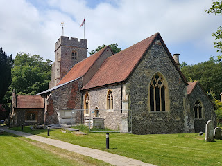 |
| St Mary's Church, North Mymms Image by the North Mymms History Project - Creative Commons BY-NC-SA 4.0 |
 |
| St Mary's churchyard, North Mymms Image by the North Mymms History Project - Creative Commons BY-NC-SA 4.0 |
From North Mymms to South Mimms
[Still to source and insert - an old picture of North Mymms Park]
"The churchyard is very pretty too, a splendid elm at the further gate is followed by an avenue of limes up to the hall but before reaching it the public thorough fare turns round to the left through one of the gates of North Mimms Park, passes a water tower, and then over hill and dale and undulating expanses of bracken it runs through woods to South Mimms about two miles further on."Alfieri is describing the bridlepath that runs south from North Mymms church to South Mimms, which is now a paved lane until the bend to North Mymms Park. At that point it's a gated track that climbs and passes woodland before crossing a valley and descending to Blackhorse Lane, South Mimms.
Entering South Mimms
[Still to source and insert - an old picture of South Mimms church]
"South Mimms lies at the bottom of the old road. After emerging from the park, and you get a glimpse of it several times before leaving the woods. It is a curious little village, and in some respects a pretty one. The church is substantial-looking, with tower and turret and clinging masses of ivy; look at it from the road at this side, facing apparently north-west: a four o’clock summer sun lights up its massive proportions, and if you can get far enough back, or as far as the road and your lens will allow, there is a picture to be made."At this point, Alfieri heads south-west on his way via Shenley to Radlett. We headed south-east and followed footpaths back to Potters Bar station and the start of the walk.
What our experts say
Alfieri So why didn't Bernard Alfieri include photographs in his book? I asked two of the North Mymmms History Project team for their thoughts on why the author included sketches instead.
Peter Miller, a local historian, archivist, and curator explains as follows:
"Many similar books of this period used drawings – H.M. Alderman in his Notes and sketches in Hertfordshire for example. I think perhaps it was because they were perceived as ‘quality’ and more upmarket than photographs, which would have appeared in newspapers and magazines."
Mike Allen, historian, photographer, and digital archivist says it could have also been because of the amount of equipment a photographer would have to carry at the time.
"Cameras in that period would still be the wooden plate cameras with real glass plates, so if you wanted 12 pictures you took six loaded double dark slides with you, plus a tripod, the camera, and the focusing cloth, which amounts to a lot of kit, I think the author was coping out by doing drawings, in the 1910s Mr Eastman had the Kodak with roll film so a big improvement, but quality was a bit iffy."
The chapter from the book
Below is the chapter setting out the walk, and further below is an embedded pdf of the entire book for you to read in full-screen, or download and print.
Download the entire book
Would you like to do this walk?
A version of this walk, with a few detours to avoid modern-day major roads, has been added to the Hertfordshire Walker site along with a map, pictures, and a detailed description of the route. You can download it free-of-charge here.



No comments:
Post a Comment
Comments on this piece
If you have any information to add to this item, please use the comment box below. We welcome input and are keen to update any piece with new research or information. Comments are pre-moderated, so there will be a delay before they go live. Thanks
Further information
If you require any further information relating to this, or any other item, please use the contact form, because we are unable to reply directly to you via this comment box. You can access it from the 'contact us' link at the top of any page on the website, at the bottom of the right hand side of the website, or at the bottom of any page.